3D Building Visualizer: see what Chicago’s zoning code allows
Published on Feb. 10, 2026 by Steven Vance
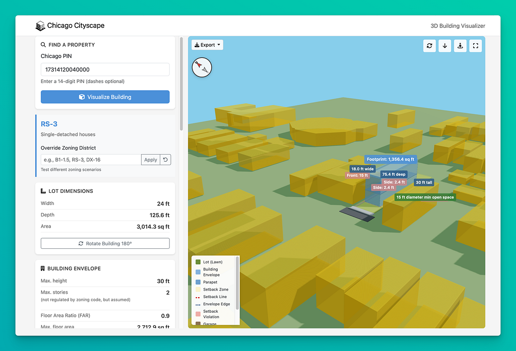
Have you ever wondered what the maximum building size is on a vacant lot or underdeveloped property? Chicago Cityscape’s new 3D Building Visualizer answers that question instantly with an interactive three-dimensional model.
The visualizer creates a real-time 3D representation of the maximum “building envelope” allowed on any property in Chicago based on zoning regulations. All the tool needs is a PIN and then watch as it generates a detailed model showing height limits, setbacks, and FAR constraints.
What to look for
Interactive 3D visualization — Rotate, zoom, and view the building envelope from any angle, including street-level perspective. We’re planning to add pedestrians and trees to make it look a little prettier.
Existing buildings layer — See nearby structures displayed in orange, providing context for how the theoretical maximum compares to what’s actually built in the neighborhood. We plan to add the CTA elevated lines.
Adjustable controls — Experiment with different setback configurations, toggle between attached and detached building types (for residential zones), and test what-if scenarios by overriding the zoning district. (This work similarly to our dwelling unit calculator.)
Multiple export formats — Download your visualization as a PDF report, PNG screenshot, 3D model (glTF), CAD file (DXF), or vector plan (SVG).
Smart calculations — The tool automatically accounts for FAR limits and offers options to maximize different dimensions — depth, width, footprint, or height. Choose “maximize height” and the building will be shown as tall as possible and still meet the maximum floor area standard.
Additional visualizations — Add a garage and a second-story coach house, calculated to fit in the rear setback and shown as the largest possible the zoning code allows. When required, the open space requirement is shown.
Start using it
The 3D Building Visualizer is currently in beta testing and open to all users. Access it directly from any Property Report’s table of contents.
Try a sample visualization of a vacant lot in McKinley Park to see the tool in action. (This is the property pictured above.)
The visualizer uses parcel geometry from Cook County and zoning standards from the Chicago Zoning Ordinance compiled it part by the Second City Zoning project. While the tool provides accurate calculations based on standard zoning rules, it may not account for all special conditions, overlays, or planned developments. It also has not been tested on all edge cases, including corner lots.
Access will be limited to Chicago Cityscape members only in the near future, so explore this powerful new tool while it’s freely available.
Contact us with your feedback!
3D Building Visualizer: see what Chicago’s zoning code allows was originally published in Chicago Cityscape’s Blog on Medium, where people are continuing the conversation by highlighting and responding to this story.
Tags
Click a tag to find more posts.
- zoning (7)
- feature_announcement (6)
Other posts by Steven Vance full archive
March 2026
February 2026
- 3D Building Visualizer: see what Chicago’s zoning code allows
📄 you're reading this one