12 features for spring 2022
Published on Mar. 28, 2022 by Steven Vance
Updated on Mar. 30, 2022
Chicago Cityscape never stops upgrading. We’ve heard valuable feedback from our members and Data Equity Cohort participants about data and new solutions that needed to be added to the platform. This is the first regularly occurring quarterly newsletter about new Chicago Cityscape improvements — there’s something for everyone.
We’ll also be demonstrating these features in a live webinar on Thursday, April 14, called “Lunch Break Update with Chicago Cityscape”. RSVP is required in order to get the Zoom link.
1. Share your access to non-members (new)
Members of the Real Estate Pro and Enterprise tiers can share their access, temporarily, with colleagues and clients. ShareLink currently works on Address Snapshot and Place Snapshot only.
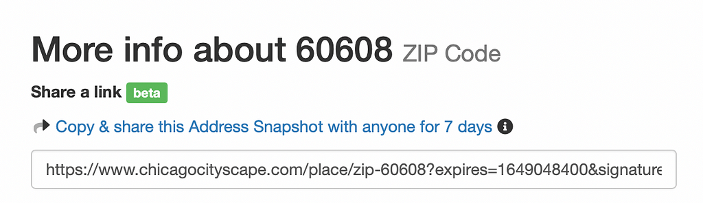
How to use it: Go to any Address or Place Snapshot and look for the “Share a link” section below the names of either snapshot. Copy the link and share!
2. Property Finder improvements
Property Finder is our most powerful feature. It helps developers of all sizes, locations, and missions efficiently find properties all across Cook County that meet their specifications. These are some of the recent improvements:
- Show Chicago-owned land and Cook County Land Bank Authority-associated properties at the same time (here’s how to use that).
- Filter by ARO area — the new regulations require that off-site units are built within the same ARO area and/or within 1 mile
- Find completely or partially vacant properties based on whether they received a reduced assessment (here’s how to find those)
3. TIF-funded projects updates
After nearly two years of not being updated by the source, the map of TIF-funded projects is flowing again. Fifty new projects have been added. This means that all of our Lending & Investment Snapshots — check out the one for Englewood — are showing the latest public sector investments (alongside NOF and SBIF-funded projects).
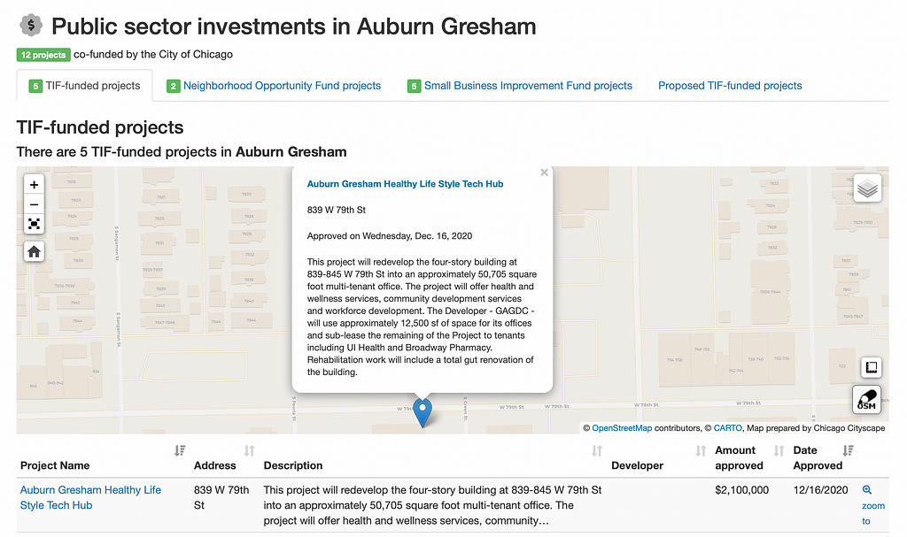
4. Proposed TIF-funded projects (new)
The TIF-funded projects shows public and private sector projects that have already been approved by the Community Development Commission, while this new dataset joins our Leads membership tier to show projects that the Chicago mayor’s administration wants to have funded by TIF. These projects may be a few months away from Community Development Commission and City Council approval.
5. Special property assessment incentive added
The Affordable Housing Special Assessment Program has launched and the Cook County Assessor is accepting applications. The owners of 7+ unit buildings are potentially eligible for “Tier 1” and “Tier 2” incentives, but only owners of properties in downtown Chicago and the downtown expansion area are potentially eligible for the “Tier 3” incentive. Look up an address and load Incentives Checker to see if that incentive is checked or not.
6. Energy benchmarking data enhanced, updated with the latest reporting
The owners of buildings with 50,000 s.f. of gross floor area are required to monitor and report their energy usage to the city. We added this data several years ago to aid climate change advocacy and track the progress of reducing energy usage. In addition, we now believe this can help in understanding a property’s market fundamentals.
We’ve added the 2020 reporting data, built brand-new filters, and created a details page for every building. Find each building’s reporting history, construction stats, and see it in context with building sizes you may be familiar with.
7. Businesses Snapshot (new)
For Place Snapshots in Chicago, the business licenses data has moved to a new page — and the new page offers two new features to help SSA and Chamber of Commerce managers:
- New business licenses issued since a specific time. By default, only licenses issued in the last 7 days are shown, but if visited after clicking on a link in a Place Snapshot email notification then business licenses issued since the date specified in the email notification are shown.
- Business types compared to similar places. Activities of different businesses are summarized in the given Businesses Snapshot and compared to others of the same Place Type; for example, one Chicago community area is compared to the 76 other community areas.
Example: 60608 ZIP code or 25th Ward
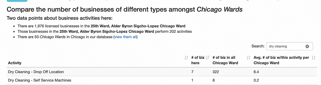
The chart above shows that there are 322 dry cleaning businesses in the 50 wards of Chicago and that there are seven in the 25th Ward, which is slightly higher than the average per ward of 6.4.
8. Cannabis: Infusers + new locations
Cannabis Compliance now shows the locations of state-licensed infusers (across Illinois, not just in Chicaog). The infusers are listed in the same map and data table as craft growers and cultivation centers. A simple filter makes it possible to instantly show a single business type at a time.
Plus, we added the locations of several more proposed and state-licensed craft growers and dispensaries. We keep a “change log” so Cityscape Real Estate Pro members can see what’s changed since they last checked.
Not a member? Start a free trial, no credit card needed.
9. Logistics facilities on a statewide map
Transportation & Jobs Snapshot has had logistics facilities for over a year, and now there’s a statewide map showing the location of 114 (at press time) distribution warehouses, Amazon, and delivery and sorting centers.
10. Amenities & social infrastructure updated
Every year, the high school-age mappers working for MAPSCorps take a “business census” of a large part of Chicago. Last year they covered the largest area of Chicago so far, and we’ve got their data on the locations of restaurants, doctors offices, convenience stores, and social services (among other categories).
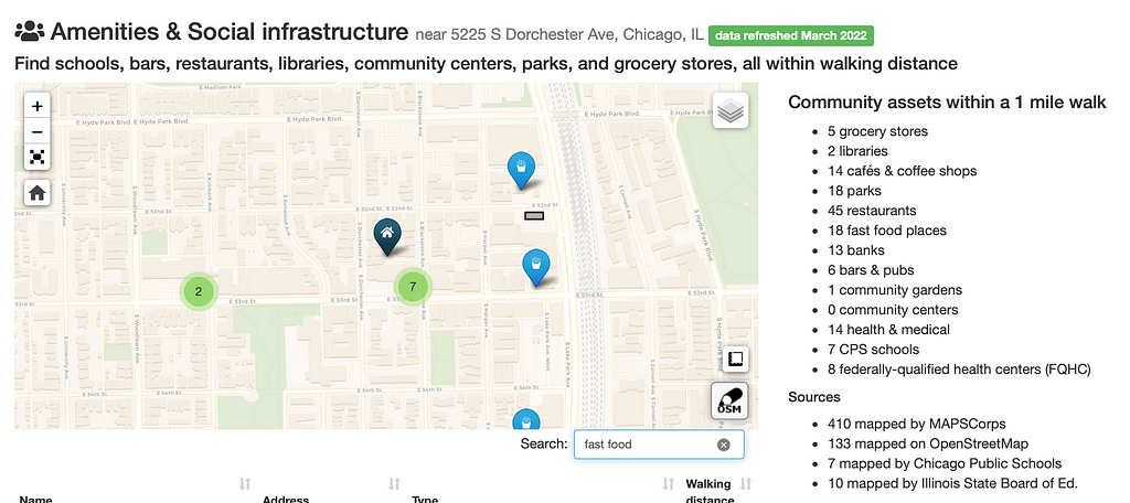
That data gets updated annually and is mixed with similar data from OpenStreetMap to ensure we have an accurate map of the amenities and social infrastructure within a one-mile walk of an Address Snapshot or contained within a Place Snapshot. Find an error? Tell us!
11. Revamped landmarks
We made a big change based on some feedback and the desire to show more: In the previous setup, members could find only the landmarks that overlapped a given Address Snapshot or Place Snapshot. Now, landmarks that are nearby can also be found.
Additionally, members can filter to show only landmarks and landmark districts matching the desired type. There are four types to show: Chicago landmarks, Chicago landmark districts, Evanston historic districts, and National Register of Historic Places. We also added the NRHP locations in Evanston!
How to use: Read our separate article about the landmarks changes.
12. New Evanston data
In addition to adding the Evanston historic districts and National Register of Historic Places districts, we’ve also added Evanston’s four Special Service Areas, added Evanston’s newest TIF district, and updated the boundary of another Evanston TIF district.
The newly added SSAs and TIF districts will appear in Incentives Checker when looking up an address or place anywhere in Evanston.
Honorable mentions
- We’ve updated the boundaries for several of the Special Service Areas in Chicago so they’re current and added a new SSA in West Garfield Park.
- Tons of new Knowledge Base articles (15 new or updated this year so far).
12 features for spring 2022 was originally published in Chicago Cityscape’s Blog on Medium, where people are continuing the conversation by highlighting and responding to this story.
Tags
Click a tag to find more posts.
- quarterly_update (14)
Other posts by Steven Vance full archive