Ten big changes we made in 2023 Q1
Published on Apr. 3, 2023 by Steven Vance
Updated on Apr. 4, 2023
Ten big feature changes we made in 2023 Q1
Our next Lunch Break Update is scheduled for Tuesday, April 18, 2023, at 12 PM. RSVP is required. These meetings showcase a handful of the new and updated features we built in the previous quarter. (We’ll select four or five from the list below — let us know if you want to see a particular feature.)
The meetings, held on Zoom, are designed to educate current members and show prospective members the kind of insights and data a Chicago Cityscape subscription offers.
Find certain kinds of building permits faster
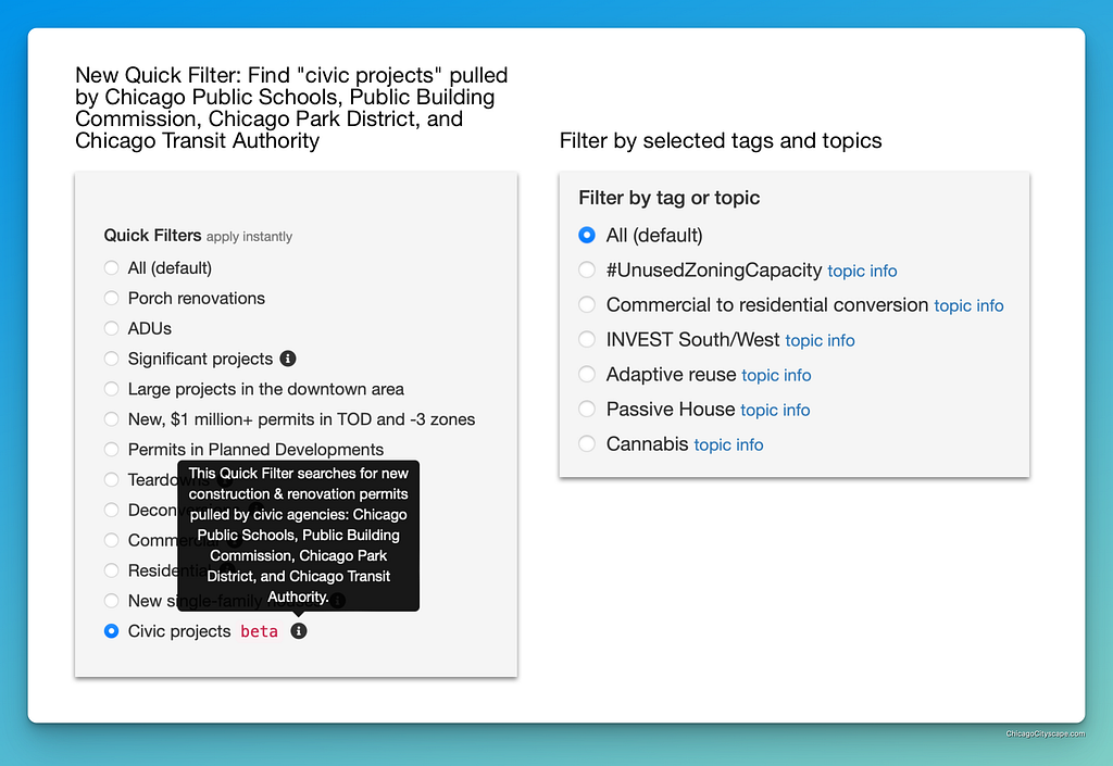
Building Permits Browser has added some pre-built filters to find permits by theme:
- Civic projects. This new Quick Filter finds building permits pulled by Chicago Transit Authority, Chicago Public Schools, the Public Building Commission, and Chicago Park District (learn more about this).
- Tags & topics filters. Find examples of adaptive reuse, commercial to residential conversion, INVEST South/West, and #UnusedZoningCapacity projects (learn more about this).
How might you use this? Say you’re a trades union and you need to see which contractors were hired for a public works project. Select the “Civic projects” radio button and instantly thousands of permits for stations, school expansions, and fieldhouse renovations appear.
Vacant Building Registry
Property Finder has data from the City of Chicago’s Vacant Building Registry (VBR). Owners of vacant buildings are required to register them and renew every six months.
Currently, only non-residential buildings and residential buildings owned by real estate companies (which includes lenders and servicers) are displayed in our Property Finder.
You’ll find the options in Property Finder’s “vacancy” section of filters — learn more about how to find vacant properties. Note that we have to update the data manually, so changes may be infrequent; send us your feedback and questions about this new dataset.
Brownfields in south and west suburban Cook County
The Cook County Department of Environment & Sustainability has highlighted some vacant properties in various west and south suburbs of Cook County.
We’ve added the majority of the properties to Property Finder. At the time of writing there were 170 parcels at 88 sites in Bellwood, Chicago Heights, Ford Heights, Franklin Park, Maywood, Melrose Park, Northlake, Schiller Park, and Sauk Village.
To help you find these faster, there’s a new custom Place Report that comprises Cook County without Chicago. Look for the “Brownfield site” filter in Property Finder’s “vacancy” section.
Promoting development in Northwest Indiana
We’re not called Northwest Indiana Cityscape yet, but we’re aware of how important the connection is between Chicago and the communities along the South Shore Line train. To support that connection we added a new Place Report type for Indiana’s seven “Transit Development Districts”.
These TDDs are small TIF districts established in 2022 around the four new stations on the West Lake Corridor extension — currently under construction — and three existing stations along the line where a second track is being added.
We don’t have property information for this area, but we do have some incentives in Incentives Checker and a small number of news articles.

Public sector investments are easier to browse
In Lending & Investment Snapshot associated with Chicago-based Place Reports, the map and data table showing public sector investment has been combined into a single view. Previously, the TIF-funded projects, et. al. had been in four separate views.
This makes it easier (and faster) to see the breadth of City of Chicago-funded projects and programs in a given area of the city. We added a filter to easily highlight projects and programs funded by a specific grant.

If you’re a grant-making organization and want to show off your philanthropy using our database, which is used by dozens of community development corporations and neighborhood advocates, please get in touch.
Property Reports pull in more data from other parts of the platform
This new feature accomplishes two things: Property Reports load faster by checking for certain data after it’s been loaded, and advises you that there is more information in one of the Property Report’s additional snapshots.
Every Property Report checks for (look in Additional Snapshots)…
- Nearby City of Chicago public sector investments
- Nearby buildings that have submitted energy benchmarking data
- Nearby environmental permits and environmental inspections
- Nearby intermodal yards and distribution & sorting centers
Plus, each Property Report checks for inclusion in any of the three most recent Annual Tax Sales and most recent Scavenger Sale (look in the Property & Ownership Info section).

Proposed Projects will include more contact info
Not all of our Proposed Projects have contact info for either the zoning change application’s applicant or the property owner. (Often the applicant and owner are the same person or entity.) We’ve always collected the application’s attorney name and law firm, but never their contact info.
Starting with the Proposed Projects submitted to City Council in March we’ll collect the zoning attorney’s contact info for the case when our members want to inquire about the project through the attorney. We’ve updated the Proposed Projects filters to allow you to show projects that have applicant or owner contact information or anyone’s contact info.
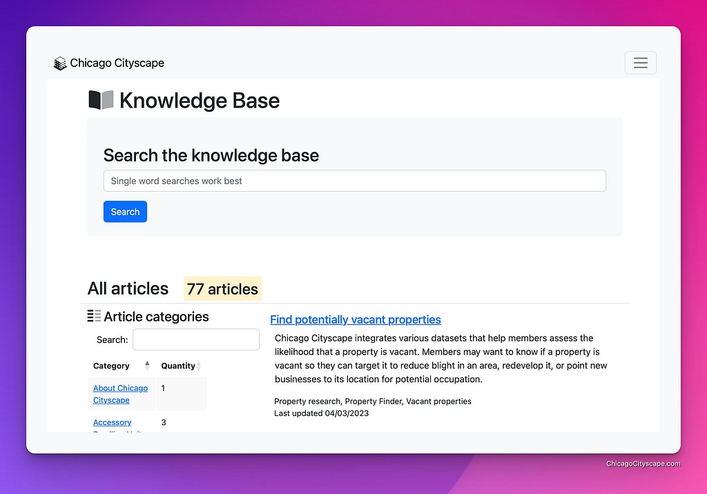
A growing Knowledge Base
Our Knowledge Base comprises 77 articles and videos that explain how to use Chicago Cityscape to accomplish certain goals as well as how to do things like research the history of a building and figure out ways to reduce how much parking your proposed development needs to provide.
What changed last quarter? We published eight new articles and updated five existing articles.
- Request a Knowledge Base article
- Watch the videos in the Knowledge Base
- Use the new Billing Portal to update your payment method
Three miscellaneous changes
(1) Aerial imagery of Cook County was updated to show photos captured in 2022. Every year, Cook County hires a crew to photograph from a plane. These images are clearer than those provided by satellites.
- Access the aerial imagery by opening any Cook County-based Property Report and selecting the “Historic imagery” button under the map.
- Look up a property now
(2) Energy benchmarking buildings’ locations in Chicago have been updated. The data came to us placing many buildings in the wrong locations, making it next to impossible to find the energy benchmarking data for a specific building.
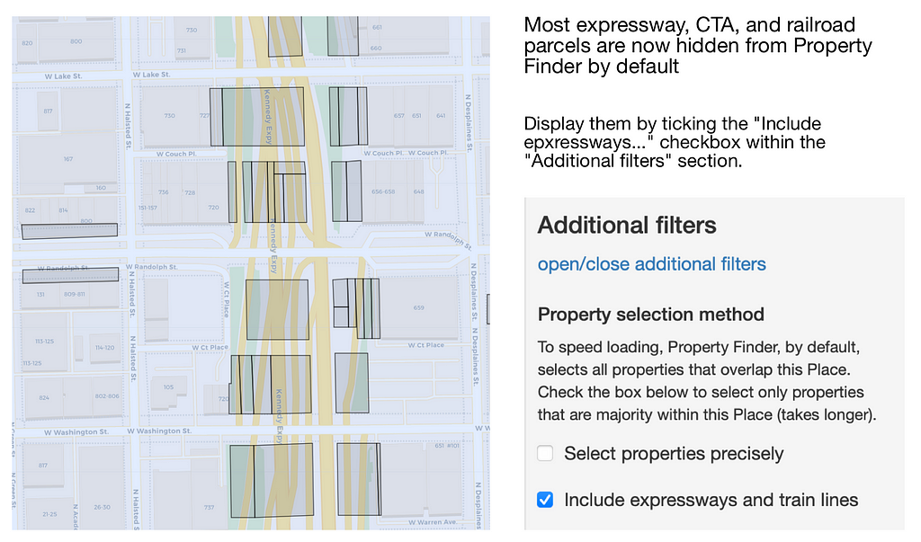
(3) Property Finder maps in Chicago look better and are more efficient as we’ve hidden 1,000s of undevelopable parcels. Specifically, parcels that are expressways or CTA or railroad rights of way are hidden by default.
- Tick a box in the “Additional filters” section to display these.
Anyone can preview selected Place Reports and Property Reports
When you find yourself excited to show your colleagues how we simplify and expand research by aggregating information about properties and neighborhoods from more than 150 data sources.
The best way for them to share Chicago Cityscape is by sending them a sample Place Report and sample Property Report.
Don’t forget to RSVP for the Lunch Break Update on Tuesday, 4/18/23.
Ten big changes we made in 2023 Q1 was originally published in Chicago Cityscape’s Blog on Medium, where people are continuing the conversation by highlighting and responding to this story.
Tags
Click a tag to find more posts.
- quarterly_update (14)
Other posts by Steven Vance full archive