New maps, data, and filters were added for affordable housing developers and advocates
Published on Apr. 28, 2021 by Steven Vance
Updated on May. 1, 2021
Chicago Cityscape is rounding out its maps showing the location and type of affordable housing beyond our existing database of only affordable housing developments in Chicago that we added in 2019. Specifically, this comprises housing developments across Illinois that are subsidized funded in part by tax credits. We also made some updates in Property Finder and Incentives Checker.
The new maps and data help our members — particularly those who are affordable housing developers (including public housing authorities, non-profit, and those that develop mixed-income housing), tenant advocates, and elected officials — know where affordable housing exists.
For example, the Illinois Housing Development Authority (IHDA) asks funding applicants to show that their proposed development would not contribute to an over-concentration of affordable housing, especially in areas with fewer amenities, jobs, and transit.
One of the values of Chicago Cityscape is that data does not explain itself. We try to explain the background of every dataset and some of the policy choices and modify descriptions and visualizations based on member feedback.
Showing housing funded by Low Income Housing Tax Credits is part of the new affordable housing maps. That program is abbreviated to “LIHTC” (pronounced lie-tech), and it refers to a federal program to let businesses offset their tax liability by investing in affordable housing and reducing their potential taxes owed. This is explained after you click “Load LIHTC…” in any Place Snapshot in Illinois (for example, look up North Lawndale).

An important aspect of LIHTC funding is a development’s attribute “year placed in service” — this is displayed in the spreadsheet that accompanies the map of LIHTC-funded developments. LIHTC for a given development lasts 30 years and the first developments turned 30 four years. It’s the number one program for funding affordable housing in the country, helping to fund 86,892 homes from 1986 to 2015 in Illinois.
When a development reaches the end of the period, there’s a potential to lose that subsidized affordable housing if the LIHTC is not renewed or another funding source isn’t found. There are around 37 developments in Illinois, representing at least 1,181 apartments, that will turn 30 this year.
Another option is for the tenants or a non-profit organization to create a cooperative or trust to take ownership of the development. Next City discussed a report from 2018 that describes the impact across the country as an increasing number of apartments reach the end of their 30-year terms.
🙀 Want a demonstration of these features and a free trial? We’ll contact you if you fill out this form, or reply to this newsletter.
More updates for our members who develop affordable housing:
- Updated IHDA Opportunity Areas, in both Place Snapshot’s and Address Snapshot’s Incentives Checker, including IHDA’s reports about the affordable housing market share in each overlapping Census tract.

- Updated Qualified Census Tracts (QCT) and Difficult Development Areas (DDA)
- Added a map of Housing Authority of Cook County (HACC) developments within each Place Snapshot
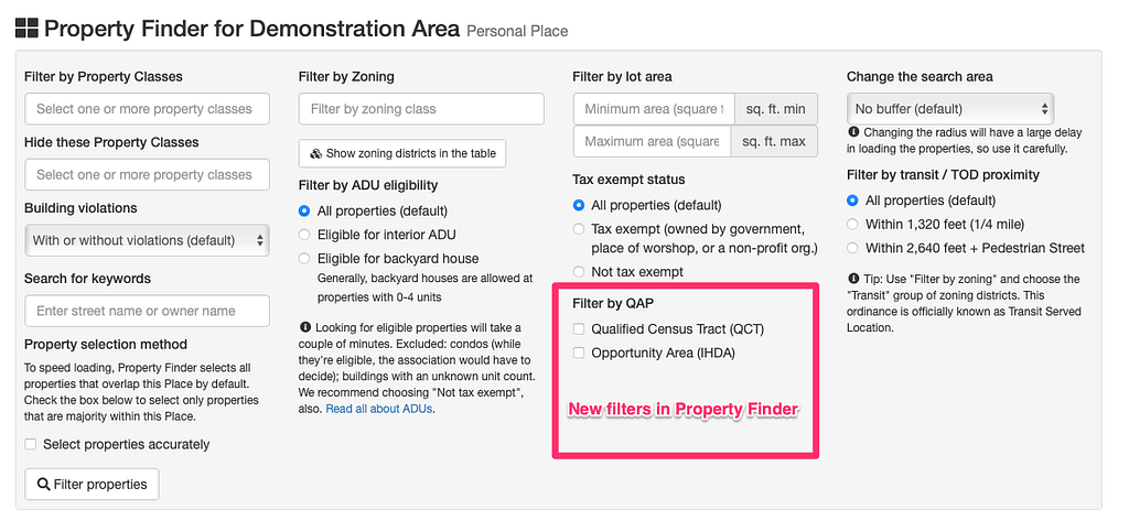
- Added Opportunity Area and QCT filters to Property Finder within each Place Snapshot (to help with finding properties that fit the parameters of Qualified Allocation Plans for locating subsidized affordable housing).
Chicago’s ARO has been revised
Note that Chicago City Council adopted major revisions to the Affordable Requirements Ordinance (ARO) last week, which take effect for building permit applications submitted on and after October 1, 2021.
The Near North, Near West, and Milwaukee Corridor pilot zones will go away, replaced by three tiers that cover larger areas (which means there are fewer gaps between zones and it won’t skip over gentrifying areas). The Pilsen and Little Village pilot zones, however, will remain in place until the end of 2023.
Chicago Cityscape has updated Address Snapshot lookups, which highlight relevant ARO geographies and their associated rules. View the map of the new geographies and how they’re listed on the Address Snapshot’s automated Zoning Assessment feature.
New maps, data, and filters were added for affordable housing developers and advocates was originally published in Chicago Cityscape on Medium, where people are continuing the conversation by highlighting and responding to this story.
Other posts by Steven Vance full archive